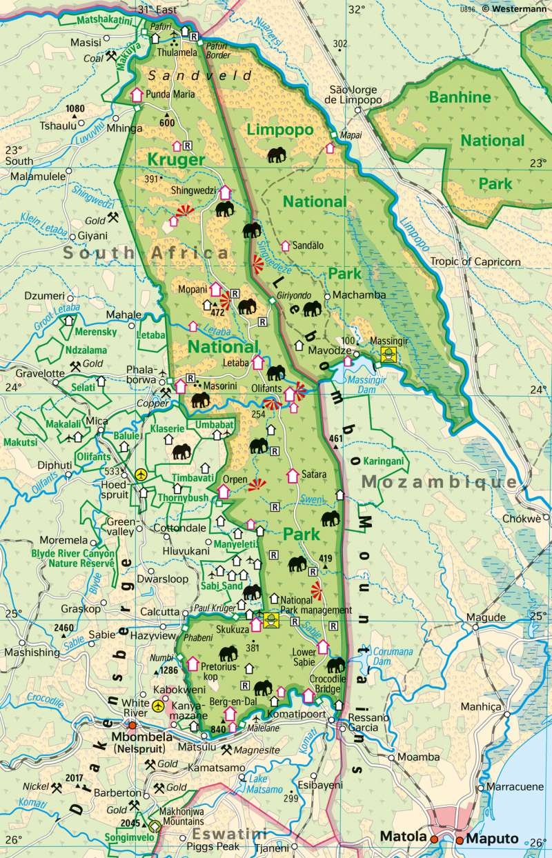
Kruger and Limpopo National Parks (Southern Africa) - Nature conservation and tourism
World heritage and topographic orientation
978-3-14-100890-6 | Page 142 | Ill. 2

Global heritage Kruger National Park
Kruger National Park (KNP) is situated about 4 hours' drive east of Johannesburg and is South Africa's oldest, largest and most popular national park. It is about 380 km long and 54 km wide on average, covering about 19,633 km² (7580 miles²). The varying basic geological structure and significantly higher average rainfall values in the south of the park form the basis for the existence of a wide variety of ecozones, in which a rich animal and plant life has been able to develop. These include the Big Five: elephant, buffalo, rhino, lion and leopard. However, these are only 5 of the total 147 mammal species in the park. There are also about 507 bird species, 118 reptile species, 49 fish species and 34 amphibian species. The flora is also rich: 404 species of trees, shrubs and bushes, 224 species of grasses and 1275 other plant species.
The park was founded by Paul Kruger, who declared the area between the Sabie and Crocodile Rivers the Sabie Game Reserve in 1889. In 1902, Scottish-born James Stevenson-Hamilton was appointed the first park ranger and headquarters were established at Sabie Bridge, now Skukuza. On 31 May 1926, the National Parks Act was passed, merging the Sabie and Shingwedzi Game Reserves into the Kruger National Park. In addition to the wildlife for which the park is world-renowned, there are 254 cultural heritage sites to visit in the park, including almost 130 rock paintings. There are numerous indications that Homo erectus already lived in this area 500,000 to 100,000 years ago. In addition, more than 300 archaeological finds from the Stone Age (100,000 to 30,000 years ago) have now been made and numerous references to the San people (Bushmen, from more than 1500 years ago) have been found.
Difference between Kruger National Park and Limpopo National Park
Since 2020, the KNP has been expanding eastwards and northwards. In direct comparison, the Limpopo National Park, which was only established on 27 November 2001, is much less well developed. To date, about 27,000 indigenous people live and farm in the area of the Limpopo National Park. Due to years of independence, civil war and hunting, the animal population was almost wiped out and due to a physical demarcation of the KNP to the east (a fence), it was not possible for animals to follow their migration routes to the east for a long time. Deterred by humans, they largely did not resume their routes even after the fences were opened from 2002 onwards. An attempt was made to resettle 10 animal species (e. g. giraffes, elephants, wildebeests, zebras, warthogs) from the KNP. As Mozambique is one of the poorest countries in the world, the establishment of tourism infrastructure has not progressed very far. In 2005, the first tourist facilities were opened in the park. The park's head office is located in Massingir. In the future, the park will be a retreat for wildlife with low tourism use and will be divided into several zones of varying intensity. A further extension towards the Great Limpopo Transfrontier Park will take place in a northerly direction around Gonarezhou National Park in Zimbabwe.
Links (as of Sept. 15, 2021):
https://www.sanparks.org/parks/kruger/tourism/history/knptourismhistory.pdf
https://www.sanparks.org/parks/kruger/tourism/history.php
https://de.wikipedia.org/wiki/Kruger-Nationalpark
https://en.wikipedia.org/wiki/Limpopo_National_Park
Tourism in Kruger National Park
The first tourists visited the Kruger National Park region after 1923, when a train stop was established at Sabie Bridge. On this section of the journey, the travellers were accompanied by game rangers and stories were told around a large campfire during the nightly stop. Thus, when Kruger National Park was established in 1926, the idea of tourism was already born. The first project was the construction of a main road with some side roads on which tourists had to pay for being accompanied by guides and for taking photos. In addition, reports written about the park and published, thus attracting more and also foreign tourists. For a fee of one pound, the first car was admitted to the national park in 1927. That year also saw the start of more significant road construction in the park. By 1934, about 800 miles or 1200 kilometres of roads had been completed. Today there are about 850 kilometres of paved road and 1444 kilometres of unpaved gravel roads in the KNP.
The first three cabins within the park were built in 1928 at Satara, Pretoriuskop and Skukuza. One year later, the first typical round rondavels with a radius of six or four metres were already erected in Skukuza and Satara. From 1930 onwards, further shelters were built at Pretoriuskop, Satara, Skukuza, Letaba, Balule (Olifants Camp), Olifants Poort (Gorge), Malelane and Lower Sabie. At that time the camps were not yet fenced. From 1931 onwards, the ronavels were equipped with windows and the first tents with 4 beds were also erected in Skukuza and Satara. One year later, the first shelters were erected in Punda Maria and Malopene. In the same year, the camps were fenced in for the first time and a first washing and bathing area was set up in Skukuza. As early as 1935, 26,000 visitors and 6000 cars were counted in the park. The last two camps opened to tourists before 1946 were Lower Sabie and Pafuri. Today, there are 21 rest camps with accommodation and 11 private lodges of the higher class in the KNP. Of the 21 rest camps, 13 are main camps and 8 are bushveld camps. The main camps offer more amenities such as restaurants, shops and fuel stations than the smaller bushveld camps and also accommodate the bulk of the over one million visitors a year. In addition, there are seven areas that have been given to private companies, where private lodges are also located.
Author:
Sarah Franz


