Sourou (Burkina Faso, Sahel) — Regional self-sufficiency in farming
Africa - Agriculture
978-3-14-100790-9 | Page 159 | Ill. 4

Information
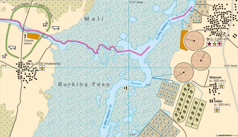
The approximately 120-kilometre-long Sourou has its source in Mali and flows into the Black Volta in western Burkina Faso. North of the confluence, immediately on the border between the two countries, is the Sourou Valley irrigation project. Its origins date back to the year 1985, when it was initiated by the government in order to improve the nutritional situation of the regional population. Over the years, the project has been supported by various foreign donors including the European Union among others. Today the irrigation project is the most important of its kind in Burkina Faso.Natural Conditions
The natural vegetation of the region is dry savannah. There, cattle and goats are pastured and drought-resistant sorghum is cultivated. The majority of the rain falls in the two rainy periods, which occur in May and June and in August and September. The average annual rainfall is 650—800 mm. But the rains are not reliable, and there are frequent dry periods — altogether not optimal conditions for agriculture.
The Irrigation Project
The irrigation started in Di. Since then, the area has been extended many times and now stretches between the settlements of Di, Niassan, Gouran and Lanfiera. In the year 2000 some 3,200 hectares of land were irrigated, but it is anticipated that in future the irrigated area to the east of the Sourou will grow to as much as 30,000 hectares. Similar projects are also planned to the west of the river.
At Léri, south of Di, a dam has been installed to control the flow of water between the Black Volta and the Sourou. In the rainy period the cyclically flowing Sourou grows into a reservoir. In the dry period, from December onwards, the dam is opened so that the direction of flow of the Sourou then changes.
Since the irrigation of the region began, wet rice has become the main product and is grown on two-thirds of the land. Maize, potatoes and sugar cane among other crops are also cultivated. A special feature is the growing of specialized crops: tomatoes and onions. Noticeable on the map are the wheat fields with their round form, determined by the type of irrigation.
Consequences for Nature and the Population
The consequences of irrigation are far-reaching. Modern farming methods alter the traditional form of agriculture, which in this dry region is characterized by sorghum grown in fields that are cleared by slash-and-burn methods. Self-sufficiency is gradually replaced by the cultivation of commercial crops. The prospering region attracts people from far afield seeking work. It remains to be seen how far this will lead to tensions between the different population groups.
Food production could only be increased at the expense of the environment. The new areas of water provide a habitat for mosquitoes and thus encourage the spread of malaria. Additionally, up to half of the water is lost to evaporation. This not only means a waste of this important resource, but also brings the danger of soil salinization.
D. Falk; Ü: J. Attfield


