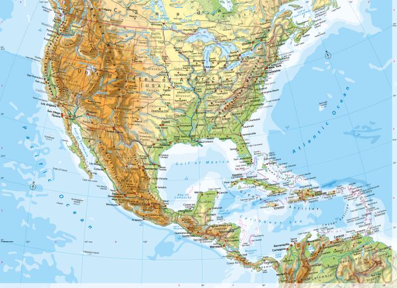
United States (USA) and Middle America - Physical map
Physical map
978-3-14-100890-6 | Page 182 | Ill. 1

Overview
In western North America, the landscape is characterised by geologically young fold mountains running from north to south. The Rocky Mountains, the Cascade Range and the Sierra Nevada have heights of over 4000 metres there. The mountain belts continue in the Sierra Madre, the high mountains of Central America and the Andes in South America. They reach their greatest width in the area of the Great Basin. South of this, large plateaus, highlands, and basins are repeatedly interspersed between the mountains. The mountains have a great influence on climatic conditions, as they act as a barrier to the dominant westerly flow of the Mid-Latitudes. On the west coast, there are widespread rising rains, while the interior of the mountains is often very dry.
Tectonics along the continental bridge
A transform fault runs through the California Longitudinal Valley, where the North American and Pacific plates move sideways past each other. Very strong earthquakes occur here time and again.
The mountain belt described has been folded in the west onto the geologically old, tectonically stable American Shield. On the one hand, this consists of wide plains (Great Plains), in which the waters form striking landmarks (Mississippi, Great Lakes). On the other hand, the Appalachian Mountains also belong to the American Shield. They are considerably lower than the Rocky Mountains, for example.
Central America includes, on the one hand, the continental bridge connecting North and South America, and, on the other hand, the Caribbean or West Indies. The Sierra Madre and its southern extensions connect the Rocky Mountains of North America with the Cordilleras (Andes) of South America and give Central America a distinctly mountainous character. Plains like those on the Yucatan Peninsula and on the coasts of the Mosquito Gulf are rare. The large cities of Central America are mostly located in mountain basins and highlands, and coastal towns are often comparatively small.
The deep-sea trenches off the Pacific coast of Mexico and in the area of the Antilles indicate plate boundaries with subduction of the oceanic crust. In the area of the Cayman Islands and in the Gulf of Honduras, the North American Plate and the Caribbean Plate move laterally past each other along a transform fault. Along the Pacific coast, the Little Coco Plate dips beneath the North American, Caribbean and South American Plates. The risk of earthquakes is therefore high throughout Central America, and numerous active volcanoes characterise the area.
The islands of the Lesser Antilles lie like a string of pearls. They form an arc whose course marks the edge of the Caribbean Plate. To the west of it lie larger islands. Cuba, at around 110,000 square kilometres, is about the size of the five new German states put together, Hispaniola about the size of Bavaria and Jamaica about the size of Rhineland-Palatinate.
Special features
- The highest mountain on the map is Citaltépetl in Mexico (5636 m).
- The greatest sea depth on the map is east of the island of Hispaniola (-9219 m). There, a deep-sea trench runs parallel to the islands of the Lesser Antilles.
- Numerous dams have been built on the Tennessee, Upper Mississippi, Missouri, and Columbia Rivers.
- Lake Maracaibo in Venezuela is almost as large as Thuringia. It is connected to the Caribbean Sea via the Gulf of Venezuela.
- The Great Salt Lake is about 1.8 times the size of Saarland and the remnant of a formerly much larger freshwater lake in the Great Basin. It has no outlet.
- Death Valley lies at -86 metres, well below sea level. The world's highest air temperature was measured there in 1913 (56.7 °C, Earth's heat record).
- In Central America, places of Indian advanced civilisations are listed (including Tikal, a ruined Mayan city in present-day Guatemala).
- Names such as San Francisco, New York, Montréal, New Orleans, and Hispaniola refer to the history of discovery and occupation by European powers, others (such as Ciudad Bolivar) to more recent history.
- On the border between the USA and Mexico are twin cities such as Tijuana - San Diego and El Paso - Ciudad Juárez.
- In the Caribbean, but also off Newfoundland and in the Pacific, there are some small islands that are overseas territories of France, Great Britain, and the Netherlands respectively.


