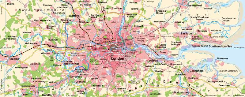
London - Monocentric metropolitan area
Urban development
978-3-14-100890-6 | Page 86 | Ill. 1

Overview
The Greater London administrative region is divided into "Inner London", the actual centre, and "Outer London", which includes the outer boroughs. The map shows the growth of the city in the suburban area. Around the relatively small City of London, which already had 500,000 inhabitants in 1700, the area expanded in a ring shape to become a cosmopolitan city with a population of around 8.5 million. At the same time, the development is increasingly tapering towards the inner edge of the Green Belt that surrounds London. In this area, new development is subject to restrictions. The Green Belt merges into a series of landscape conservation areas that extend into the South East region.
Transport axes and hubs, New Towns
Beyond the Green Belt are numerous settlements of varying ages, linked to inner parts of London by a system of railway lines and regional roads. Three quarters of the UK's air passenger traffic is handled by the three largest London airports alone. These are London Airport Heathrow - with 80.9 million passengers in 2019 the largest airport in Europe -, Gatwick Airport (south, outside the map section; 46.6 million passengers) and Stansted Airport (north-east, also outside; 28 million passengers).
Due to its location near the mouth of the Thames, London was an important port city for centuries. Technical, urban planning and economic reasons have led to the abandonment of the old port facilities in recent decades. At the same time, modern ports such as the Tilbury container port have been built downstream from the Thames. At the former Shell Haven refinery site west of Canvey Island, the London Gateway is currently being developed, a superlative container port with a direct rail connection and an extensive logistics and business park.
Immediately beyond the Green Belt are towns that in recent decades have either been newly founded as planned towns, like the "New Towns", or in which population settlement has been promoted to relieve the metropolitan area. Large parts of the population of these towns work in London. Almost the entire south-east of England is part of the commuter area of the metropolis. In order to contain the strong population increase (see diagram of population development 86.2), which was mainly caused by immigration, and the associated land-intensive suburban growth, various planning concepts for the decentralisation of industry, commerce and population were developed after 1945. One of the primary goals was to transform the monocentric metropolitan area into a polycentric area with urban counterparts in order to relieve the centre.


